


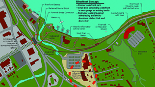
An overview of the Riverfront Concept in Middletown.
Riverfront Development Covers South Cove, Highway, Sound
MIDDLETOWN - A small boat launch ramp at the intersection of Silver Street and River Road; a nature trail along the shoreline; an environmental education wetlands; a link of River Road to a 1.5-mile network of bike trails and lanes running along Harbor Park; an enhancement of the tunnel access as a major gateway to the riverfront; a new community boat house and a new rowing facility--these developments are among many that Middletown residents can expect from a recently approved plan to develop the Harbor Park Connecticut Riverfront. Those plans can be found in the Middletown Riverfront Redevelopment Commission Final Report published in June.This report and the Economic Development Riverfront General Fund were unanimously approved by the Middletown Common Council.
As reported in the September issue of The Chronicle, another document, â€Ĺ"A Placemaking Plan for the Middletown Riverfront,” finalized by Project for Public Spaces in January 2014, has become the â€Ĺ"guiding vision for future riverfront development.”
Three questions were not discussed in the Chronicle’s September issue; the first was should the City of Middletown incorporate a quasi-public, nonprofit riverfront development corporation?
The Commission recommended the establishment of a Riverfront Authority similar to the Long Hill Estate Authority, which authorizes â€Ĺ"various types of bonding...tied to income and revenues from particular projects...and bonds backed by the full faith and credit of the City.”
The Authority would manage tasks such as maintenance and repairs, events and programming, tenant and concession management, fundraising and marketing and promotion. The Commission Report stated that â€Ĺ"the rents and income collected within the riverfront area [would] be used to manage and improve the riverfront area.”
The commission also suggested that a separate, nonprofit corporation, like the Friends of Long Hill Estate, Inc., might also be established for the riverfront, using the public authority, and 501(c)(3), to undertake many of the projects proposed by Project for Public Spaces, which â€Ĺ"require public-private grants, capital campaigns and charitable contributions.”
Major public improvements can also be accomplished through bonding and through state and federal funds.
The second question was what, if any, changes to existing highway patterns will be required to responsibly develop riverfront property and how can Middletown best interact with the state DOT to ensure efficacious planning?
The city supports the DOT’s addressing of safety concerns about the ramp from Route 17 to Route 9 and the state’s proposal to close the Harbor Drive ramp and construct a bridge at the end of Union Street over Sumner Brook. The city is asking the state to relocate River Road between the railroad crossing and Eastern Drive, and suggesting the consideration of a pedestrian walkover across Route 9.
The city recommends negotiation with the state about the â€Ĺ"potential use of land on the north side of Silver Street and refining the City zoning plan to control the future use of land if it were sold to a private developer.”
The city proposes the â€Ĺ"conveyance process be initiated for the area of the steeply sloping unused state land..that fronts along the railroad.”
South Cove
The third question has two parts: (1) Should the city seek conveyance of state land adjacent to the South Cove area or parcels of contiguous land and what should be done with such space as it relates to the South Cove development? and (2) Should the South Cove development be tied to further development at Harbor Park?”
The area known South Cove comprises the waterfront area just south of Harbor Park, along both sides of River Road between Union Street and Eastern Drive. In 2000, Middletown residents recommended that â€Ĺ"South Cove should include a large waterfront park, boat access to the river and outdoor entertainment and recreation facilities that would support high quality commercial and residential development on nearby privately-owned parcels.”
City planners encourage â€Ĺ"lighter, quicker, cheaper experiments [that] allow for lower risk and lower cost improvements to become the launching pad for a larger, long-term plan,” which will include creative ideas to produce the most effective ways to link the riverfront to Main Street.
A Three-Year
Implementation Plan:
The objectives for year one include for communication to increase between government and private sectors and for community awareness; construction of the pedestrian and bike trails and the Sumner Brook bridge; investigating the rezoning of the entire area for private development proposals while retaining control over the use and design; working with the Canoe Club for improvements, signage and advertising and energy upgrades, all of which would makeit an attractive destination in central Connecticut.
Protecting the Sound
The MRRC Report also emphasized that Middletown â€Ĺ"owes its existence to” this 410-mile river. A new draft proposal for a 20-year plan to protect Long Island Sound was released in September as the â€Ĺ"Long Island Sound Study.” It was written by a coalition of local, state and federal agencies, environmental groups and business organizations to address problems created by more frequent and fiercer global-warming-induced storms and rising sea levels.
Some of those challenges are: â€Ĺ"preventing sewage overflow and improving stormwater treatment; creating new systems to monitor algae and oxygen depletion in the Sound, reducing the amount of nitrogen from sewage and fertilizer draining into rivers and streams that feed into the Sound; and devising new laws to prevent new development and infrastructure construction in coastal flood zones” (Hartford Courant, Sept. 8, 2014).
The proposal also addresses relocating key coastal facilities like oil tanks and power stations, among other measures.
The Hartford Courant quoted Leah O’Neill, Long Island Sound coordinator for the U.S. Environmental Protection Agency’s Boston office: â€Ĺ"One of the group’s top challenges is to improve the resiliency of our coastal communities.”
The MRRC Plan for Connecticut’s Riverfront is already taking into account the problems mentioned above and expects to incorporate any recommendations made by this new plan, when its final report is completed by January 2015.
The Connecticut River Estuary and Tidal River Wetlands Complex begins at the mouth of Long Island Sound and continues upstream for 36 miles to Cromwell and Wangunk Meadows just north of Middletown. With â€Ĺ"its extensive, high-quality tidal freshwater and brackish marshes and remarkable clusters of rare and endangered species,” the river was recognized as an internationally important wetland” at the Ramsar Convention in Iran on October 14, 1994. The Connecticut is among 2,127 Ramsar-designated sites found in all geographic regions of the world.
In 1995, the entire Connecticut River watershed was named the Silvio O. Conte National Fish and Wildlife Refuge. In 1998 the Connecticut River, nominated by the governors of four New England states in the river valley, was named one of just 14 rivers nationwide receiving the designations of â€Ĺ"An American Heritage River.”
In May 2012, U.S. Interior Secretary Ken Salazar designated the Connecticut as America’s first National Blueway, saying â€Ĺ"restoration and preservation efforts on the river were a model for other American rivers.” Lastly, the national Nature Conservancy named the Connecticut and its estuary as â€Ĺ"one of the last great places” on the planet.